- About Us
- Columns
- Letters
- Cartoons
- The Udder Limits
- Archives
- Ezy Reading Archive
- 2024 Cud Archives
- 2023 Cud Archives
- 2022 Cud Archives
- 2021 Cud Archives
- 2020 Cud Archives
- 2015-2019
- 2010-2014
- 2004-2009
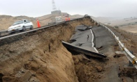 |
April 2010 - An Earth On Fire |
Introduction
Natural disasters remind us that the earth is far from inert. Perhaps we don’t entirely forget, but it is easy to focus on things other than the usually stable mass beneath our feet. Until a cracking headline grabs our attention. We had almost forgotten about Haiti when recently a volcano beneath the Eyjafjallajokull Glacier in Iceland began spewing ash into the atmosphere. The resultant ash cloud wreaked havoc on airline flights across the Northern Hemisphere and thousands of travelers were left stranded at airports from Heathrow to Singapore.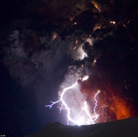
For the most part, compared with our relatively exciting surface life the solid earth is simply boring. However, while the geological clock by which our earth moves is slow and gradual, its hands are both powerful and final. Furthermore, if we believe geologists we really tread upon quicksand:
To the geologic eye all the surface of the earth is a fluid form and man moves upon it as insecurely as Peter walking on the waves to Christ: Will and Ariel Durant[i]
This essay describes recent events in the geological record, and makes use of the scientific literature to find and report on consensus explanations for their occurrence. The Boxing Day Tsunami, Haiti and Chilean earthquakes are described, and the established theory of plate tectonics is evoked as their driving force. Because plate tectonic theory is crucial to the understanding of not only earthquakes and volcanoes, but also the physical evolution of the earth, most time is spent describing it. Finally, this essay provides a brief coverage of the state of play in earthquake prediction, early warning and mitigation.
A troubled past
History is littered with extraordinary volcanic eruptions, earthquakes and mass extinction events – from the passing of dinosaurs to Vesuvius, Krakatoa, the Great Chilean Earthquake of 1960 and the Mt St Helens eruption in 1980. Accordingly, scientists understand that immense forces shape the surface of the earth. Yet these surface features themselves are only one part of the earth’s evolution and their sculpting forces are dwarfed by much larger geological phenomena. Surprisingly, much of the action is beneath our feet.
The earth’s story is told in fragments - glimpses and snapshots provided to geologists, physicists, chemists and other keen observers.
Sometimes, the installments are not so subtle.
At 00:58:53 UTC on December 26, 2004 an earthquake with an epicentre off the west coast of Sumatra, Indonesia, displaced a mass of water sufficiently large to generate devastating tsunamis. These fast moving swells inundated nearby coastlines and led to the deaths of over 230,000 people in fourteen countries. We remember the event as the Boxing Day Tsunami.
Anatomy of disaster
This earthquake is known to geologists as the Sumatra-Andaman[ii]. It was the second largest earthquake ever recorded, at magnitude moment 9.2, and was felt simultaneously in Thailand, Indonesia, Singapore, Malaysia and the Maldives. During the Sumatra-Andaman, about 1,600 kilometres of earth was shifted and the entire planet vibrated by one centimetre[iii]. The event lasted nearly ten minutes, another record for measured earthquakes, and triggered earthquakes as far away as Alaska[iv].
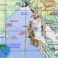
(Photo source: NASA/United States Geological Survey)
The Sumatra-Andaman event started off the coast of Aceh with a rupture occurring at a depth of 30 kilometres below the ocean floor. The rupture spread to the ocean floor and proceeded North West at a terrifying speed of approximately 10,000 km/h. Sections of the earth’s crust began popping up around the site of the fault, in some instances as much as 20 metres, displacing approximately 30km3 of water and generating waves up to 30 metres high[v]. The force of the rupture, most violent in proximity to the epicentre, was eventually dissipated over many thousands of kilometers.
The tragic effects of the tsunamis are well known.
Sumatra-Andaman was what geologists’ term a “mega thrust event”. This occurs when sufficient pressure builds up in the earth to cause parts of it crack and break. The cracks are called “faults” and an earthquake occurs when the earth is displaced at the site of the fault. In Sumatra-Andaman, very large sections of the earth slipped at the site of a fault deep below the seafloor. “Thrust” refers to the relative movement of the sections of earth on either side of the fault – one forced over the other. For example, consider two fists being pushed against each other. Eventually something gives – one goes up, one goes down. Because the shallow earth is brittle, the slip is typically violent.
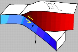
(Photo Source: United States Geological Survey)
Once again the earth was rocked and devastated by earthquakes, early in 2010. At 16:43 local time on 12 January 2010 a magnitude 7 earthquake activated 13 kilometres underground, 25 kilometres to the west of Port-au-Prince, Haiti[vi]. According to Haiti Government sources, some 230,000 people died, 300,000 were injured and 1,000,000 were rendered homeless. Entire towns were destroyed, including widespread disablement of infrastructure and utilities. Then, on February 27 an earthquake off the coast of Chile was so severe that it moved the earth’s axis by 8 cm and shortened the length of the day by 1.26 microseconds. Hundreds of people died, thousands were injured, and many more made homeless by the effects of the earthquake and multiple tsunamis. GPS measurements indicate that the entire city of Concepcion was moved 3 metres to the west by the earthquake[vii].
Many in the media have asked if there has been a sudden increase in apparently unrelated catastrophic earthquake events in recent years. A closer examination of the scientific literature reveals that the three recent earthquakes described above are not isolated; in fact they are related by the same broad geological setting, similar underlying driving forces, and a curiously named feature.
A pacific ring of fire
The Sumatra-Andaman, Haiti and Chile earthquakes occurred within the Pacific Ring of Fire[viii]. At first it sounds like an Indian Restaurant best avoided, but it’s also the informal term for a zone of concentrated earthquake and volcanic activity that surrounds the Pacific Ocean. More formal geological names include circum-Pacific Belt or circum-Pacific Seismic Belt. It is a horseshoe shaped fracture in the earth that stretches from New Zealand to Indonesia and Japan, skirting Kamchatka (Russia) and then follows the west coast of North America to the southern tip of South America[ix]. The total distance is about 40,000 kilometres. Historically it is home to over 90% of the world’s earthquakes and houses 452 active volcanoes. For example, the famous San Andreas fault that has terrorised the residents of San Fransisco for hundreds of years, is a lateral ‘spur’ line to the Pacific Ring of fire. The feature is a network of very large faults that delineate the boundary of a block section of the earth’s crust – the Pacific Plate.
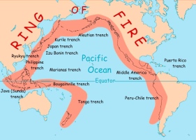
(Photo Source: National Oceanic and Atmospheric Administration)
Why is there a Pacific Ring of Fire? The explanation for this geological phenomenon draws on a number of important theories, namely plate tectonics and its associated theories.
And a giant jigsaw puzzle….
According to established geological theory, the earth’s surface is similar to a jigsaw puzzle. However, unlike a regular puzzle the pieces are not fixed – they are constantly, yet slowly moving. The pieces of the puzzle are vast regions of earth known as tectonic plates, for example the Pacific Plate mentioned above.
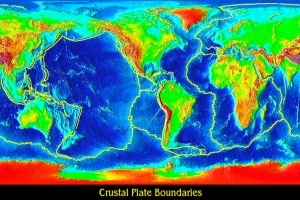
(Photo Source: http://geology.about.com)
The tectonic plates represent the earth’s lithosphere - the upper regions of the earth which are composed of hard, brittle rock. The brittle nature of tectonic plates renders them prone to crack under the pressures that build up in the earth, resulting in earthquakes. Plates are distinct from continents, as plates span across oceans and continents and vice versa. For example, a plate boundary slices through the South Island of New Zealand. Continents merely reside on plates, as do oceans.
Below the plates lies the earth’s asthenosphere which is composed of very hot, ductile material that is believed to flow in the fashion of melted plastic. The soft, flowing nature of the asthenosphere supports the movement of the rigid tectonic plates above it.
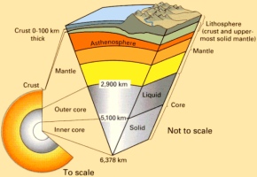
(Photo Source: University of Oklahoma)
The tectonic plates are separated by faults that spread for thousands of kilometers across the earth’s surface and deep below it. Smaller faults extend throughput the plates themselves. These fissures provide weaknesses which are the sites of very large earthquakes. The Pacific Ring of Fire is the giant fissure that surrounds the Pacific Plate.
The theory of plate tectonics was the result of parallel developments in related investigations – continental drift, seafloor spreading, subduction zones and large scale fault zones.
Continental drift theory originated from the ingenious interpretations of early global maps[x]. Observers in the early 20th century noticed complementarities between the opposing coastlines of major continents. This led them to believe that the continents had once been joined prior to gradually drifting apart.
At about the same time, seismologists were mapping concentrations of earthquakes and volcanic activity parallel to large linear structures such as sub sea ridges, mountains and faults. Further mapping of these zones led to the theory that large, relatively stable plates were surrounded by plate boundaries characterized by intense seismic and volcanic activity[xi]. In combination with continental drift, the theory emerged that tectonic plates are spread across the earth’s surface and that over thousands and millions of years they plot slow and convoluted courses across the globe. They periodically butt up against and move away from each other.
A further critical discovery was made in the early 1960’s. Oceanographers, in cooperation  with the US Navy, noticed confused magnetic signals emanating from the ocean floor. Further investigation revealed widespread linear magnetic stripes, thousands of kilometers in length that spaced apart at regular intervals. When mapped, the magnetic stripes represented a zebra-like pattern. Interestingly, the stripes alternate in polarity, suggesting that the earth’s magnetic field periodically reverses. The magnetic field of an igneous rock[xii]effectively snaps frozen in place when it crystallises, due to alignments in the crystal structures of iron and magnesium-rich minerals. This provides a record of the earth’s magnetic field at the time of the rock’s formation.
Symmetrical, linear magnetic striping around the crests of mid ocean ridges supported a theory of seafloor spreading.
Scientists were also able to map out ‘Wadati-Benioff’ zones (after the geologists who discovered them), which are earthquake zones extending deep into the earth at 40-60 degrees from horizontal. These delineations were then accurately interpreted as the outlines of tectonic plates being forced back down into the asthenosphere at collisional plate boundaries[xiii].
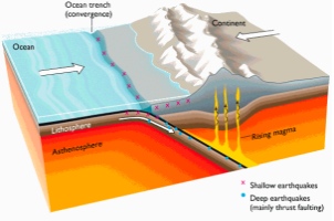
(Photo Source: Northwestern University)
From Wadati-Benioff Zones and seafloor spreading, it became apparent that tectonic plates spread and converge. The material that comprises plates is generated at mid ocean ridges and then it is ‘subducted’ back into the mantle. The divergent zone is called a divergent plate boundary – an example is a mid ocean ridge. Where plates collide, a convergent plate boundary exists. Twisted and compacted strata in the rock record and the earthquakes themselves are testament to the tremendous forces involved.
Once the theory of plate tectonics was established, the final great problem to be solved was the explanation of the plate movements and the buildup of such forces to cause earthquakes.
The earth’s engine room
Although not settled, the theory with current sway is that dissipation of heat from the mantle drives tectonic plate movements[xiv]. Just as in air, warm material rises and then cools and sinks – a process called convection. Scientists believe that giant convection cells exist in the earth’s mantle. The very hot, plastic-like material circulates with variations in temperature and chemical composition. Large scale mapping of the earth’s interior using seismic tomography reveals substantial lateral variations in density of the mantle, due to mineral and chemical composition and temperature. The currents resulting from the convection cells are postulated to drive movement of tectonic plates around the globe.[xv].
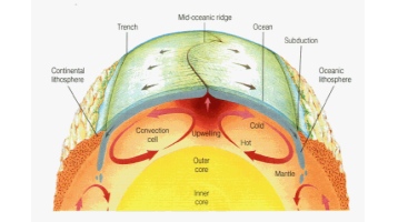
(Photo Source: Ohio State University)
The hot material rising through the mantle during convection, sometimes escapes to the earth’s surface as magma, where it cools and solidifies. The surface expression is a continental or oceanic volcano. The continued process of material forcing its way to the surface causes the newly formed crust to spread away from its source as per the observations of magnetic striping theory. Furthermore, as the new crust spreads away from its source, it cools and becomes denser, gradually sinking back into the mantle and thereby dragging the plate across the globe. This theory is backed up by extensive mapping of plate spreading boundaries, showing elevations at the site of the spreading, and decreasing elevation with further distance away from it. This process of plate recycling is also believed to be very important for life on earth, assisting in the balance of carbon and other elements between the earth and the atmosphere. Subduction zones are also the site of violent volcanic eruptions, due to the incorporation of sea water and other volatiles with the subducting plate.
The long term movement of tectonic plates led to the present configuration of continents on the globe. However, as alluded above it hasn’t always looked like it does today. The fossil record attests that areas that are now land, were once submerged under sea. The continents have periodically been joined as supercontinents and then broken up. Previous iterations of supercontinents include Rodinia (1 billion years ago), Gondwana (550 million), Pangea (250 million years ago) and Laurasia (200 million years ago)[xvi].
Back to reality
The scientific developments described above have led to a startling picture of the earth’s inner workings. Given we know this much, can’t we predict or prevent the disasters taking place?
Only partly.
On Boxing Day 2004, there was a lag of several hours between the Sumatra-Andaman earthquake and the resultant tsunamis, yet most people were completely caught by surprise. The statistics are tragic, such as the high proportion of female and child casualties, because they were waiting on the beaches for the fishermen to return.
There was no tsunami early warning system in place.
An extensive network of tsunami early warning systems exists in other parts of the Pacific but not in the Indian Ocean because it is part of a region historically less seismically active. Since the Boxing Day tsunamis, the UN has worked to set up such a network. An intricate network of sensitive buoys and seafloor monitors is required for early warning, given that tsunamis only create large waves when they reach shallow water, when it is too late.
Prediction
Elsewhere, governments of earthquake prone countries such as China and Japan have thrown vast resources into earthquake prediction and 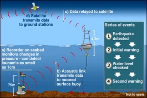 early warning. Notable successes include the successful prediction and evacuation prior to the Haicheng earthquake (China, 1975) and Gushan-Pianling (China, 1999). However, notable failures include the Tangshan earthquake (China, 1976) and the Great Hanshin earthquake (Japan, 1995). Furthermore, active earthquake prediction activity results in many false alarms – with over 30 issued in China in the late 1990’s. This leaves one with the feeling that the science is quite imprecise and relies on a healthy measure of luck.
Methods for predicting earthquakes include seismic patterns, electromagnetic fields, and changes in the chemical composition of soils, ground movements and even animal behaviour. Many have been shown to be valid for isolated instances but none to be recurrent indicators of an impending earthquake with any reasonable lead time. Predictions are more about the probability of a certain sized earthquake happening over a number of years rather than certain days or months.
Early warning
Early warning is the regional notification of an earthquake while it is in process or commencing. This involves monitoring and communications equipment. Electromagnetic sensors have picked up an increase in activity due to electromagnetic signals released from the fracture of crystalline rock deep in the earth as a rupture is occurring.
Research is focusing on the early seismic signature of small and large earthquakes and whether or the eventual size of an earthquake can be ascertained early in its occurrence.
Avoidance and mitigation
The most important tool in the avoidance of earthquakes is the mapping and measurement of earthquake prone areas such as the Pacific Ring of Fire. The measurement and mapping of earthquakes allows seismologists to create rough probabilities that certain sized earthquakes would occur over a period of time and to advise authorities accordingly. Urban planners must also be cognizant of such information.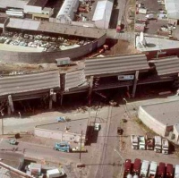 For example, the 7,000 strong town of Chaiten in Chile was relocated in 2009 from the foot of the Chaiten Volcano which reactivated after lying dormant for thousands of years. Although in other cases an understanding of the risks has not stopped areas being built up in close proximity to them. For example, San Francisco lies on a major fault line and numerous villages, towns and cities of the world lie in direct proximity to active volcanoes.
The last and most important line of defence in an earthquake is mitigation. Engineers may argue that earthquakes do not kill people, falling buildings do.
The technology is not complex. The builders of Machu Picchu, located in a seismically unstable zone in Peru, utilized mortarless bricks that move and adjust during a tremor, thus absorbing and dissipating the forces. Similarly, modern day seismic engineering is about building structures that can dissipate the forces that are transmitted to them from the earth. A number of options exist, such as spring-based dampers in a building’s foundations, to block based dampers that raise the structure above the ground. Other methods are more sophisticated. For example, Taipei 101, the world’s second tallest building contains a tuned mass damper. This is a 660 tonne pendulum suspended between the 92nd and 88th floors, that sways to offset any movement of the building as a result of strong gusts of wind or earthquakes.
Such engineering has been shown to be very successful in reducing the damage and loss of life during an earthquake. In the Chile earthquake of February 2010 the prevalence of well-engineered buildings was reported as one of the reasons for the relatively lower loss of life when compared with other similar earthquakes. However, earthquake resistant cities are the exception rather than the rule, and we will remain susceptible to unpredictable seismic and volcanic events that have the potential to cause widespread destruction and deaths for a long time to come.
Therefore, while we may lay claim to the grand theories of the earth, we’re still well behind on the practicalities as they relate to protecting our villages, towns and cities and avoiding humanitarian disasters.
The earth’s violent internal processes are perhaps a mirror of the violence on the earth’s surface. We will continue our uncertain tenure on the globe, but the earth will have the last say.
With that, the final words belong to Durant (1926):
Civilisation exists by geological consent, subject to change without notice
Cameron O’Neill is a former geologist and now investment banker based in Sydney. He writes for the Cud in his spare time. Daniel Coombes is a postgraduate student in law at the University of Melbourne.
If you would like to donate to Oxfam’s aid programs that include earthquake reconstruction, please go to: http://www2.oxfam.org.au/trailwalker/Sydney/team/207 and support our fundraising efforts. Alternatively, you can support the Humanitarian Early Warning Service: http://www.hewsweb.org/home_page/default.asp
Footnotes:
[i] Durant, W & Durant, A., 1968, Lessons of History.
[ii] Lay, T., Kanamori, H., Ammon, C., Nettles, M., Ward, S., Aster, R., Beck, S., Bilek, S., Brudzinski, M., Butler, R., DeShon, H., Ekström, G., Satake, K., Sipkin, S., The Great Sumatra-Andaman Earthquake of December 26, 2004, Science, 308, 1127–1133
[iii] Ibid.
[iv] West, Michael; Sanches, John J.; McNutt, Stephen R. "Periodically Triggered Seismicity at Mount Wrangell, Alaska, After the Sumatra Earthquake." Science. Vol. 308, No. 5725, 1144–1146.
[v] Tsunamis and Earthquakes: Tsunami Generation from the 2004 Sumatra Earthquake - USGS Western Coastal and Marine Geology
[vi] Magnitude 7.0 – HAITI REGION Tectonic Summary. United States Geological Survey, 12 January 2010
[vii] http://earthquake.usgs.gov/earthquakes/eqinthenews/2010/us2010tfan/
[viii] http://vulcan.wr.usgs.gov/Glossary/PlateTectonics/description_plate_tectonics.html
[ix] The earth’s crust refers to the 30km average depth below the earth’s surface, a low density brittle layer of rock that overlies the dense, hot mantle
[x] Wegener, A., 1915. The Origins of Continents and Oceans
[xi] Carey, S.W., 1958. The tectonic approach to continental drift
[xii] An igneous rock is formed from the cooling of magma, either deep in the earth or at the earth’s surface in the form of lava.
[xiii] Hanus, Vanke and Krs, 1979. Morphology of the Wadati-Benioff zone, andesitic volcanism, and active fracture zones in Central America. Studia Geophysica et Geodaetica.
[xiv] The earth is made up of the core (inner and outer), mantle (inner and outer) and crust. The crust refers to the hard outer layer of the earth that varies in thickness from 5km to 60km. The mantle comprises most of the volume of the earth and is comprised of a hard upper layer and a more plastic, ductile lower layer. Beneath this resides the earth’s core, composed of high density lead and nickel. The distinction between the crust and the mantle is based on chemistry, density and seismic properties. The earth is also divided into the lithosphere and asthenosphere. The lithosphere-asthenosphere boundary marks the transition from solid to semi-fluid state in the earth. The lithosphere comprises the upper mantle and the crust.
[xv] Kent C. Condie (1997). Plate tectonics and crustal evolution
[xvi] Ibid.
